HISTORY OF THE
CLAYTON MINE
Clayton Silver Mine Operations
Highlights
- Mining Operations 1935 – 1986
- Absentee owner in 1980s used older mining methods.
- Inferior mining techniques and old processing equipment diluted grade milled
- Mining ended in mid 1980’s due to low metal prices with active mine operations still in mineralization.
- The historic production disclosed from the Clayton Silver Mine, mainly of silver, lead and zinc, has an aggregate present value of approximately USD $347 million+ based on current spot metals prices.
Clayton Silver Mine History
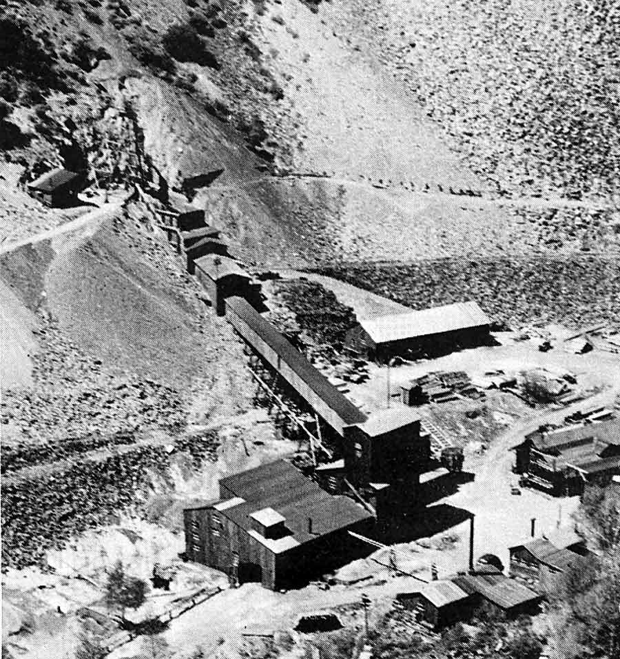
The Clayton Silver Mine, discovered in 1877, and historically one of the most active mines in the Bayhorse Mining District in central Idaho, was an underground Pb-Zn-Cu-Ag mine. The Clayton Silver Mine was one of the largest silver producers in Custer County, Idaho and in the state of Idaho outside of the Coeur d’Alene district. Prospect mining at the Clayton Silver Mine site began in 1927 (Clark Mining Co.), at which time the property consisted of 25 patented and seven unpatented claims and was known as the Camp Bird Group. Mining was sporadic until 1935. The Clayton Silver Mine, one of nearly 50 in the district, was largely operational from 1935 through 1986. Until mining operations ceased in 1986 due to low metal prices, records indicate the mine produced approximately 7 million Troy ounces of silver, 86.8 million pounds of lead, 28.2 million pounds of zinc, 1.7 million pounds of copper, and 1,454 Troy ounces of gold from an estimated 2,145,000 tonnes of ore. It is likely that even greater amounts of minerals were mined and recovered considering the lack of production records in the early years of the mine’s operation.
The Company has compiled and comprehensively reviewed available historical drilling and mining information for the Clayton Mine and the Clayton Silver Property. Information available in the public domain was obtained from both the United States and Idaho Geological Surveys. Several sub-surface mine plans were obtained from private sources, as well as the U.S. Department of the Interior, Office of Surface Mining. These data provide the basis for an initial compilation of the sub-surface workings tied to surface. The underground workings are flooded and inaccessible and, consequently, historical records are the only source of information available.
Clayton Silver Mine History
The Clayton Silver Mine, discovered in 1877, and historically one of the most active mines in the Bayhorse Mining District in central Idaho, was an underground Pb-Zn-Cu-Ag mine. The Clayton Silver Mine was one of the largest silver producers in Custer County, Idaho and in the state of Idaho outside of the Coeur d’Alene district. Prospect mining at the Clayton Silver Mine site began in 1927 (Clark Mining Co.), at which time the property consisted of 25 patented and seven unpatented claims and was known as the Camp Bird Group. Mining was sporadic until 1935. The Clayton Silver Mine, one of nearly 50 in the district, was largely operational from 1935 through 1986. Until mining operations ceased in 1986 due to low metal prices, records indicate the mine produced approximately 7 million Troy ounces of silver, 86.8 million pounds of lead, 28.2 million pounds of zinc, 1.7 million pounds of copper, and 1,454 Troy ounces of gold from an estimated 2,145,000 tonnes of ore. It is likely that even greater amounts of minerals were mined and recovered considering the lack of production records in the early years of the mine’s operation.
The Company has compiled and comprehensively reviewed available historical drilling and mining information for the Clayton Mine and the Clayton Silver Property. Information available in the public domain was obtained from both the United States and Idaho Geological Surveys. Several sub-surface mine plans were obtained from private sources, as well as the U.S. Department of the Interior, Office of Surface Mining. These data provide the basis for an initial compilation of the sub-surface workings tied to surface. The underground workings are flooded and inaccessible and, consequently, historical records are the only source of information available.
Clayton Silver Mine
Underground Workings
Clayton Silver Mine Operations
Historical Data:
- Clayton Mine developed on 8 levels to 1100 ft depth with 19,690 feet of underground development.
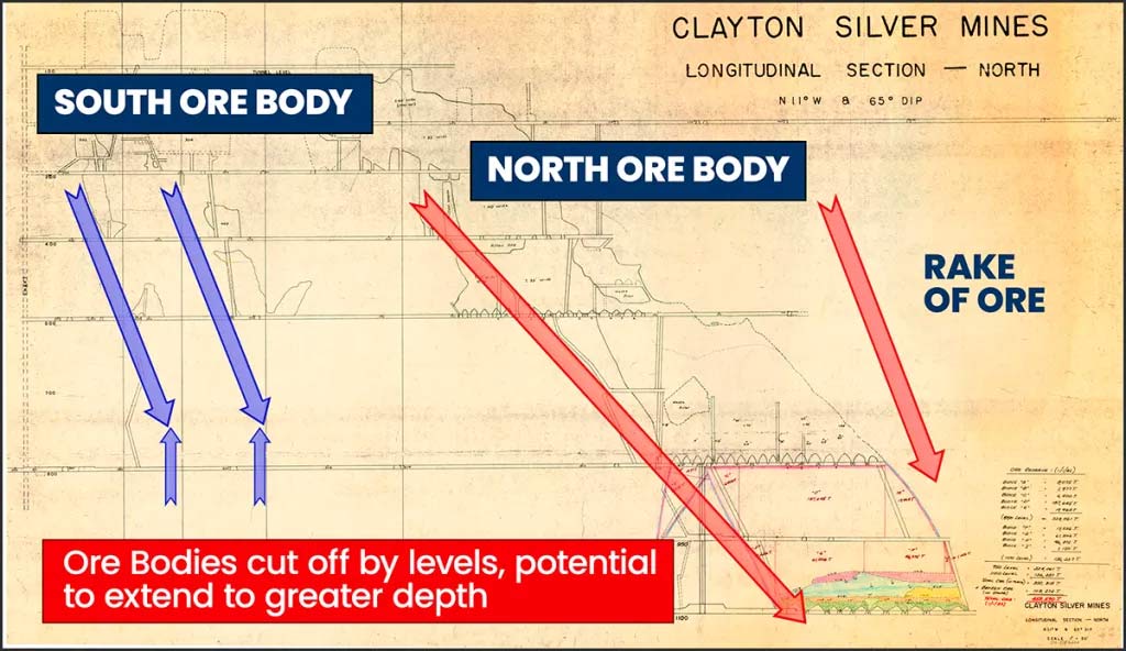
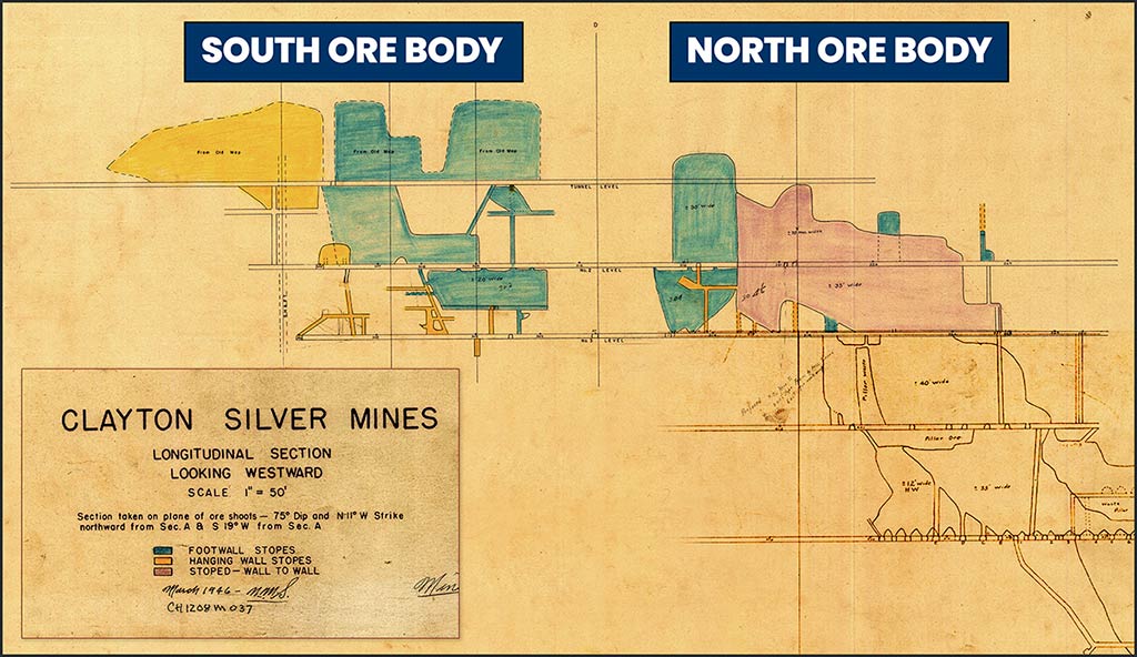
- Two major ore bodies developed: “South” & “North”
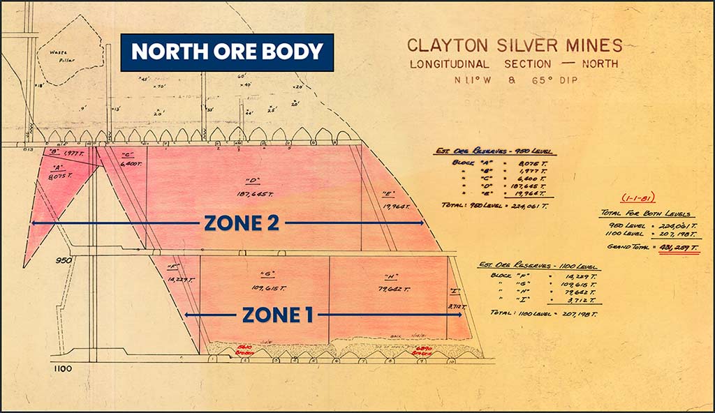
- Mine records indicate mineable ore in North Ore Body at time of closure
- Additional tonnage down to 1530 ft level not mined.
- Interpretation indicates open to depth additional potential east and west of South Ore Body workings.
Historical Drilling:
- Previous drill holes suggest upside potential
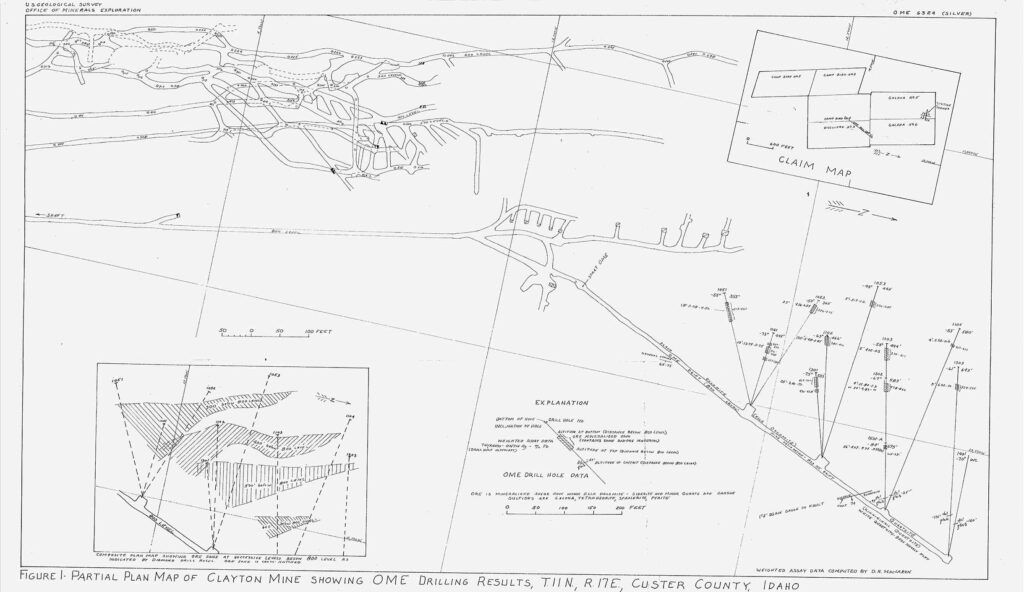
- Confirms North Ore Body mineralization below 1100 ft depth of old mine workings to at least 1500 ft depth.
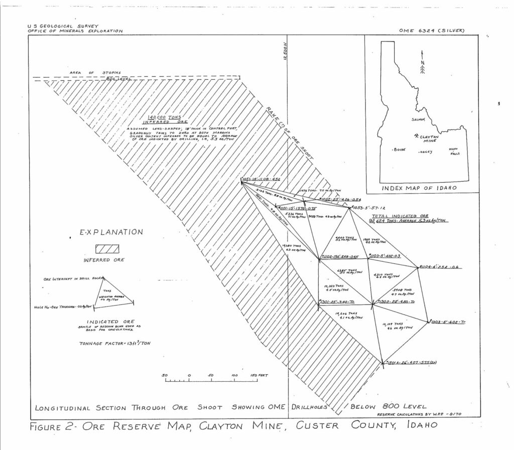
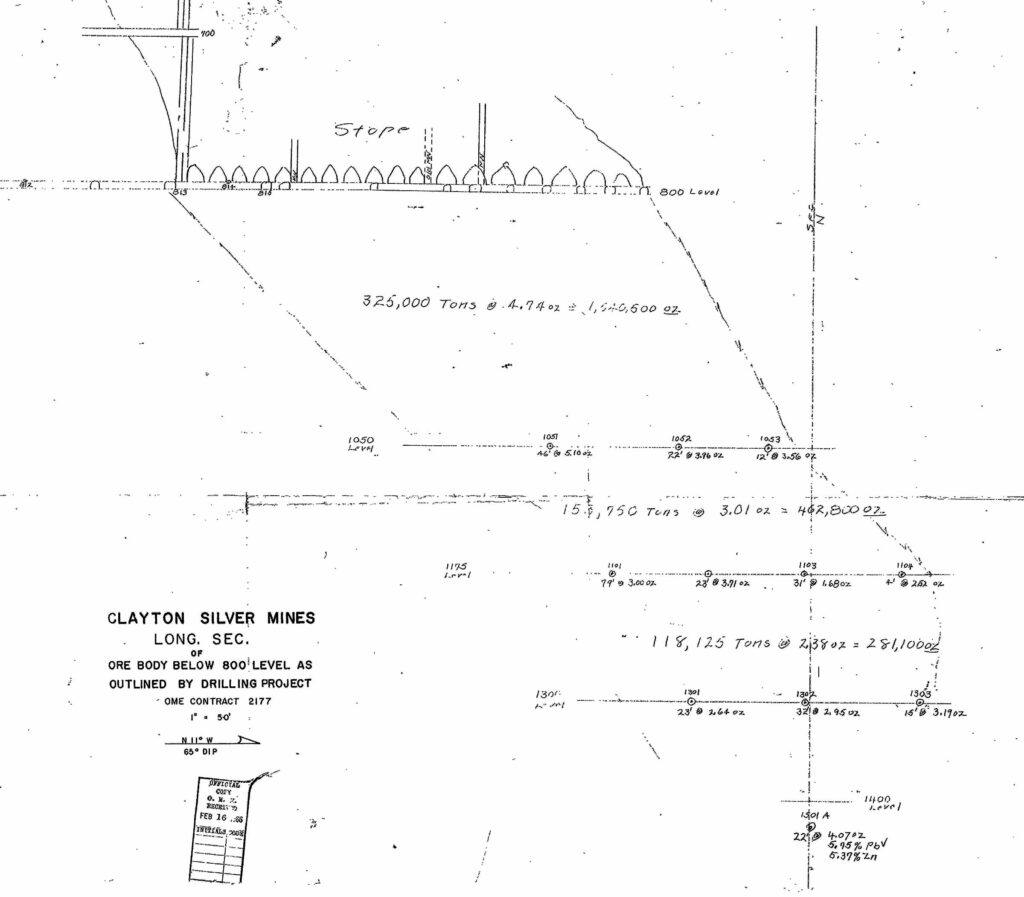
- 1960s drill hole 1501-A intersected 22 ft of mineralization at 1425 ft level with grades of: silver 4 oz/ton, lead 5.75%, zinc 5.37%.*
Longitudinal of Workings
Two major ore bodies were partly mined: the “South Ore Body” and the “North Ore Body”. Both are tabular ore bodies raking northeast to depth. Production was initiated on the South Ore Body and development extended to the North Ore Body. Mineralization is open to the north, the south and to depth, all of which is untested. For example, there is potential for resources to exist at shallower depths below and adjacent to the South Ore Body.
Historical records indicate the South Ore Body was mined from the 100-foot level to the 800-foot level, while the North Ore Body was mined from the 100-foot level to the 1,100-foot level. Internal mine records from 1966 indicate a resource of 597,075 tonnes between the 800-foot level and 1300-foot level, having a weighted average grade of 3.83 oz Ag/t. Values for lead and zinc were not disclosed. Underground development on the 800-foot level was extended to the North Ore Body, with subsequent development down to the 1100-foot level to access the ore.
Mine Longitudinal Section
Records indicate that as of January 1, 1982, there were approximately 458,590 tonnes of ore identified between the 800 and 1100 foot levels. Of this resource, 52,800 tonnes were mined in 1983, 76,110 tonnes in 1984 and 102,258 in 1985, suggesting 227,422 tonnes have not been mined. Additional tonnage identified down to the 1530-foot level was not mined and, therefore, is interpreted to remain available. Significant potential is demonstrated in hole 1501-A, drilled in the mid-1960’s, which penetrated the mineralized zone at 1,425 feet. At that depth, the hole intercepted 22 feet of 4.07 oz Ag/t, 5.75% lead and 5.37% zinc (note: true width is unknown).

